


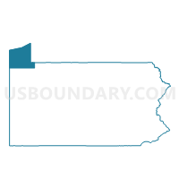
Voting Districts not defined, Erie County, Pennsylvania
About
Outline

Summary
| Unique Area Identifier | 659616 |
| Name | Voting Districts not defined |
| County | Erie County |
| State | Pennsylvania |
| Area (square miles) | 753.72 |
| Land Area (square miles) | 0.00 |
| Water Area (square miles) | 753.72 |
| % of Land Area | 0.00 |
| % of Water Area | 100.00 |
| Latitude of the Internal Point | 42.25127880 |
| Longtitude of the Internal Point | -80.16851550 |
Maps


Graphs
Select a template below for downloading or customizing gragh for Voting Districts not defined, Erie County, Pennsylvania


Neighbors
Neighoring Voting District (by Name) Neighboring Voting District on the Map
- Voting District 000000, Chautauqua County, NY
- Voting District 007999, Ashtabula County, OH
- Voting District 240001, Chautauqua County, NY
- Conn 4-A Voting District, Ashtabula County, OH
- ERIE WD 01 DIST 04, Erie County, PA
- ERIE WD 01 DIST 05, Erie County, PA
- ERIE WD 01 DIST 06, Erie County, PA
- ERIE WD 01 DIST 08, Erie County, PA
- ERIE WD 04 DIST 01, Erie County, PA
- ERIE WD 04 DIST 06, Erie County, PA
- ERIE WD 04 DIST 08, Erie County, PA
- FAIRVIEW TWP DIST 01, Erie County, PA
- FAIRVIEW TWP DIST 02, Erie County, PA
- GIRARD TWP DIST NORTH, Erie County, PA
- HARBORCREEK TWP DIST 01, Erie County, PA
- HARBORCREEK TWP DIST 02, Erie County, PA
- HARBORCREEK TWP DIST 03, Erie County, PA
- LAKE CITY Voting District, Erie County, PA
- LAWRENCE PARK TWP DIST 01, Erie County, PA
- LAWRENCE PARK TWP DIST 02, Erie County, PA
- MILLCREEK TWP DIST 04, Erie County, PA
- MILLCREEK TWP DIST 05, Erie County, PA
- MILLCREEK TWP DIST 06, Erie County, PA
- MILLCREEK TWP DIST 13, Erie County, PA
- MILLCREEK TWP DIST 15, Erie County, PA
- NORTH EAST TWP DIST 01, Erie County, PA
- NORTH EAST TWP DIST 02, Erie County, PA
- SPRINGFIELD TWP Voting District, Erie County, PA
Top 10 Neighboring County Subdivision (by Population) Neighboring County Subdivision on the Map
- Erie city, Erie County, PA (101,786)
- Millcreek township, Erie County, PA (53,515)
- Harborcreek township, Erie County, PA (17,234)
- Conneaut city, Ashtabula County, OH (12,841)
- Fairview township, Erie County, PA (10,102)
- North East township, Erie County, PA (6,315)
- Girard township, Erie County, PA (5,102)
- Lawrence Park township, Erie County, PA (3,982)
- Springfield township, Erie County, PA (3,425)
- Lake City borough, Erie County, PA (3,031)
Top 10 Neighboring Place (by Population) Neighboring Place on the Map
- Erie city, PA (101,786)
- Conneaut city, OH (12,841)
- Northwest Harborcreek CDP, PA (8,949)
- Lawrence Park CDP, PA (3,982)
- Lake City borough, PA (3,031)
- Avonia CDP, PA (1,205)
Top 10 Neighboring Unified School District (by Population) Neighboring Unified School District on the Map
- Erie City School District, PA (101,798)
- Millcreek Township School District, PA (53,503)
- Harbor Creek School District, PA (17,234)
- Conneaut Area City School District, OH (14,670)
- Northwestern School District, PA (12,097)
- Girard School District, PA (11,237)
- North East School District, PA (10,609)
- Fairview School District, PA (10,102)
- Iroquois School District, PA (7,323)
- Ripley Central School District, NY (2,056)
Top 10 Neighboring State Legislative District Lower Chamber (by Population) Neighboring State Legislative District Lower Chamber on the Map
- Assembly District 150, NY (121,520)
- State House District 99, OH (108,338)
- State House District 2, PA (62,337)
- State House District 3, PA (60,723)
- State House District 4, PA (58,468)
- State House District 5, PA (58,143)
- State House District 1, PA (55,982)
- State House Districts not defined, OH (0)
Top 10 Neighboring State Legislative District Upper Chamber (by Population) Neighboring State Legislative District Upper Chamber on the Map
- State Senate District 32, OH (311,809)
- State Senate District 57, NY (285,036)
- State Senate District 49, PA (241,903)
- State Senate District 21, PA (235,571)
- State Senate Districts not defined, OH (0)
Top 10 Neighboring 111th Congressional District (by Population) Neighboring 111th Congressional District on the Map
- Congressional District 14, OH (648,128)
- Congressional District 3, PA (640,356)
- Congressional District 27, NY (629,271)
Top 10 Neighboring Census Tract (by Population) Neighboring Census Tract on the Map
- Census Tract 102.01, Erie County, PA (6,145)
- Census Tract 102.02, Erie County, PA (5,522)
- Census Tract 104, Erie County, PA (4,832)
- Census Tract 103.04, Erie County, PA (4,651)
- Census Tract 1.01, Ashtabula County, OH (4,554)
- Census Tract 105, Erie County, PA (4,390)
- Census Tract 3, Erie County, PA (4,214)
- Census Tract 114, Erie County, PA (3,982)
- Census Tract 2, Erie County, PA (3,957)
- Census Tract 115.03, Erie County, PA (3,713)
Top 10 Neighboring 5-Digit ZIP Code Tabulation Area (by Population) Neighboring 5-Digit ZIP Code Tabulation Area on the Map
- 16505, PA (17,168)
- 44030, OH (16,652)
- 16428, PA (12,478)
- 16511, PA (11,382)
- 16507, PA (11,088)
- 16415, PA (8,916)
- 16423, PA (4,450)
- 14775, NY (2,537)
- 16411, PA (1,477)